Description

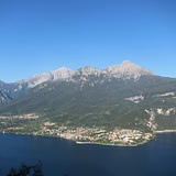
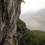
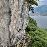
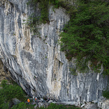
A high-end crag located above Valbrona, with a stunning panoramic view over the Lecco branch of Lake Como and the Grigne mountains.
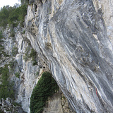
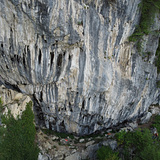
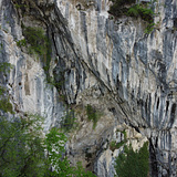
Climbing here is steep and demanding: compact overhangs up to 40° in the lower sector, while the upper sector features beautiful tufas and highly three-dimensional movement. Routes are well equipped, and many lines have fixed steel quickdraws.

🪨 Base: comfortable on the right, steeper and more exposed in the central section. A small ledge (“pulpit”) can host only a few climbers (pay attention!).
🌤️ Exposure: southeast (sun in the morning, shade in the afternoon)
🍂 Best season: spring to mid-autumn, with ideal conditions in spring and autumn
💨 Conditions: well sheltered from the wind; can be climbable even in light rain if previous days were dry. After rainy periods (especially in spring), some holds may stay wet

⚡ The crag is mostly dedicated to advanced climbers, with a high concentration of routes in the 8b–8c+ range, a true testpiece area in the region.

👣 Approach: ~15 minutes
🚫 Not suitable for beginners or families

History

The crag was developed by Mauro Sormani, Giacomo Rusconi, and Marco Vago, with contributions from a few others.

It hosts two of the hardest routes in Triangolo Lariano region:
- The Party Is Here 9a (FA Gabriele Moroni, 2019)
- Megageremia 9a (FA Stefano Carnati, 2020)

Valbrona Bassa

Access is sensitive!

🚗 Access

From Milan: follow SS36 towards Lecco and exit before the Monte Barro tunnel onto the Lecco–Erba–Como road (direction Pusiano). Continue to Erba, then take the tunnel towards Canzo. Pass through Canzo and continue to Asso, following signs for Valbrona.
In Valbrona, turn right near a small church at the end of the village (just after the sports field on your left), and follow the road uphill towards Rifugio SEV.
From Lecco: follow the lakeside road towards Bellagio until Onno, then head to Valbrona. Turn left just after the church and continue as described above.

Follow the paved road for about 200 m. Park approximately 40 m before the waste collection area on the left.

🅿️ Parking
Primary parking: 45°52’58.8”N 9°18’17.8”E
If full, park near the sports filed: 45°52’53.6”N 9°18’02.5”E

🥾 Approach (20 min)

Take the first dirt road on the left. Reach a meadow below a house (near a small storage box). Cross the meadow and continue through the woods to a clearing, with a hunting hut down on the left. This section crosses private property, please be respectful and pass through quietly ❗️
From here, head right and uphill on a trail. Continue to a ledge and gully section which is exposed and requires caution. This leads to the first sector, currently closed. Follow fixed ropes up to a ledge to reach the main sector.
The upper-left sector is accessed via a gully, bypassing the tower on the left.

❗️⚠️ Notes ⚠️ ❗️

Access to the crag is exposed and potentially dangerous. Not suitable for children.
Park only along the paved road.
Do not leave any litter at the crag or along the approach.
Do not stop or leave belongings in the meadow near the storage box, as it is private property.